Jinmeng Rao

I am a research scientist at Mineral, Alphabet Inc. I was a research scientist and AI resident at Google [X]. I got my PhD in Geographic Information Systems (GIS) and my MS in Computer Sciences (CS) from University of Wisconsin-Madison, working with Prof. Song Gao in the Geospatial Data Science Lab. Before that, I got my BS and MS in GIS from Wuhan University, working with Prof. Qingyun Du and Prof. Shiliang Su.
I work on machine learning, deep learning, geospatial data science, and computational agriculture. In particular, I am interested in developing and incorporating AI approaches into geospatial domains to tackle real-world challenges such as trajectory prediction and generation, location recommendation, spatial data privacy and security, food systems, etc.
Recent News [ more... ]
| Oct 2023 | Our multiple papers are accepted for NeurIPS 2023 workshops as posters. |
|---|---|
| Oct 2023 | Our work on multimodal LLM hallucination is accepted for Google Research Conference 2023. |
| Oct 2023 | I served as the PC member of the SoLaR workshop at NeurIPS 2023. |
| Oct 2023 | Our arXiv preprint on spatial-spectral super-resolution is online. |
| Sep 2023 | Our full research paper on conditional trajectory generation is accepted for IJGIS. |
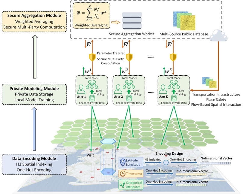
| Sep 2023 | Our paper on private&secure GeoAI foundation models is accepted for ACM SIGSPATIAL 2023. |
| Sep 2023 | Our arXiv preprint on agnosia of multimodal large language models is online. |
| Sep 2023 | I served as the PC member of the GeoAI workshop at ACM SIGSPATIAL 2023. |
| Aug 2023 | Our arXiv preprint on vision language reasoning is online and will be presented at BayLearn 2023. |
| May 2023 | Our arXiv preprint on open-vocabulary attribute recognition is online. |
| May 2023 | I served as the co-chair of the GeoIndustry workshop at ACM SIGSPATIAL 2023. |
| Apr 2023 | Our full research paper on smart foodsheds is accepted for IEEE CG&A. |
Selected Publications [ more... ]
2023
-
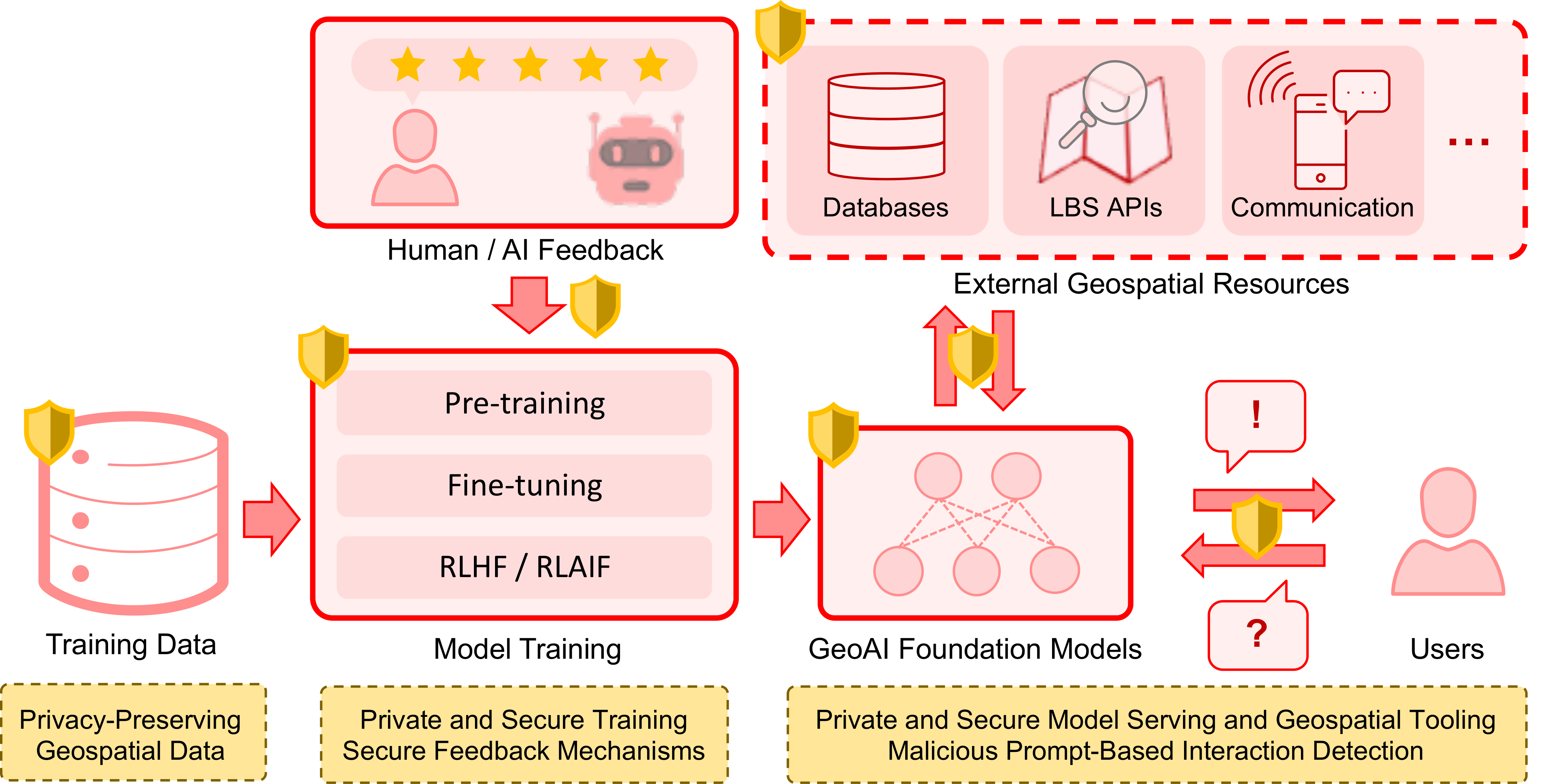 ACM SIGSPATIALBuilding Privacy-Preserving and Secure Geospatial Artificial Intelligence Foundation ModelsIn Proceedings of the 31st International Conference on Advances in Geographic Information Systems, 2023Highlight: Top Conference in Geographic Information Systems; Acceptance rate 37.2%
 -
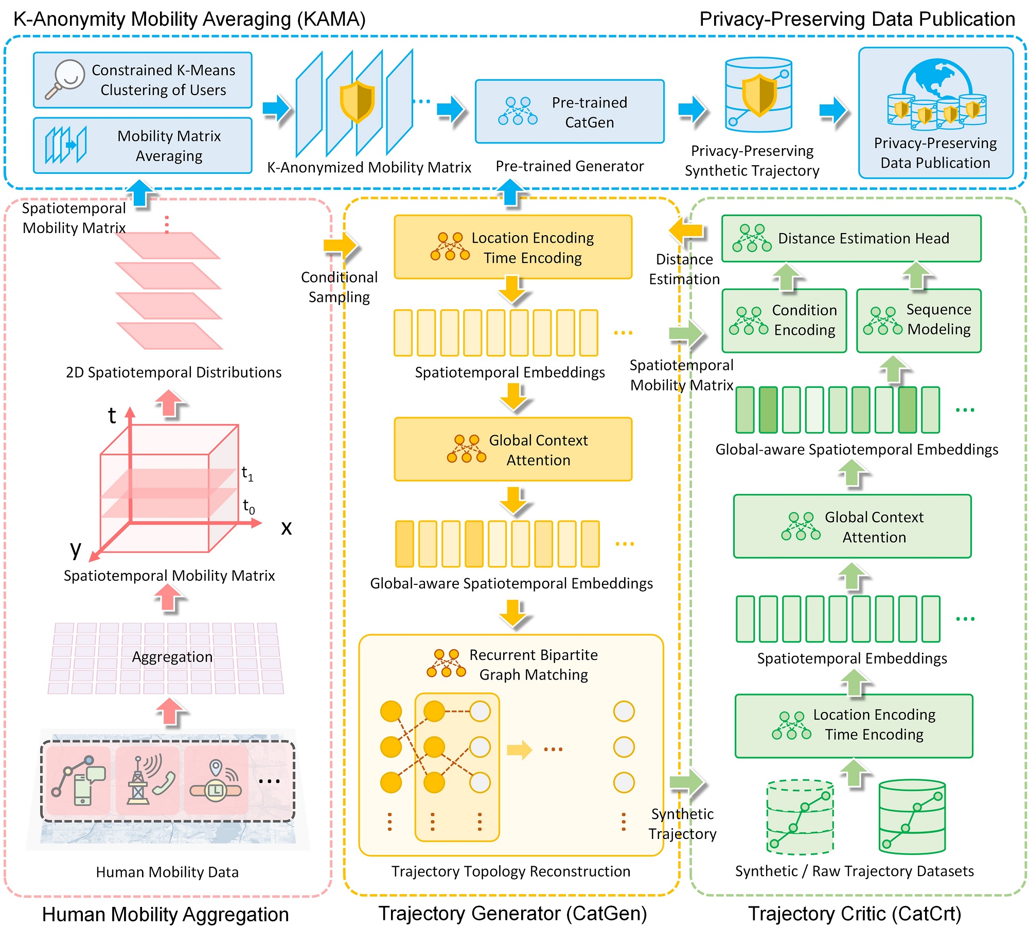 IJGISCATS: Conditional Adversarial Trajectory Synthesis for Privacy-Preserving Trajectory Data Publication Using Deep Learning ApproachesInternational Journal of Geographical Information Science, 2023Highlight: Top Journal in Geographic Information Science; SCI Q1 in CS, IS and Geography; Acceptance rate 12%
 -
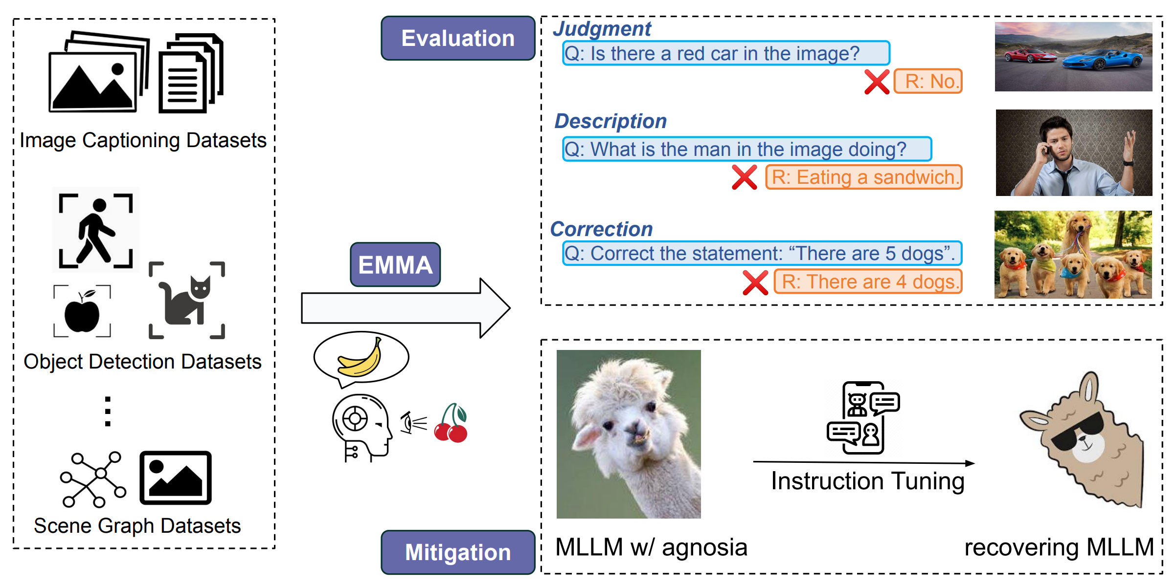 Google Research ConferenceEvaluation and Mitigation of Agnosia in Multimodal Large Language ModelsarXiv preprint arXiv:2309.04041, 2023Highlight: Trustworthy Multimodal Foundation Models; Multimodal Instruction Tuning; The poster version to be presented at Google Research Conference 2023


2022
-
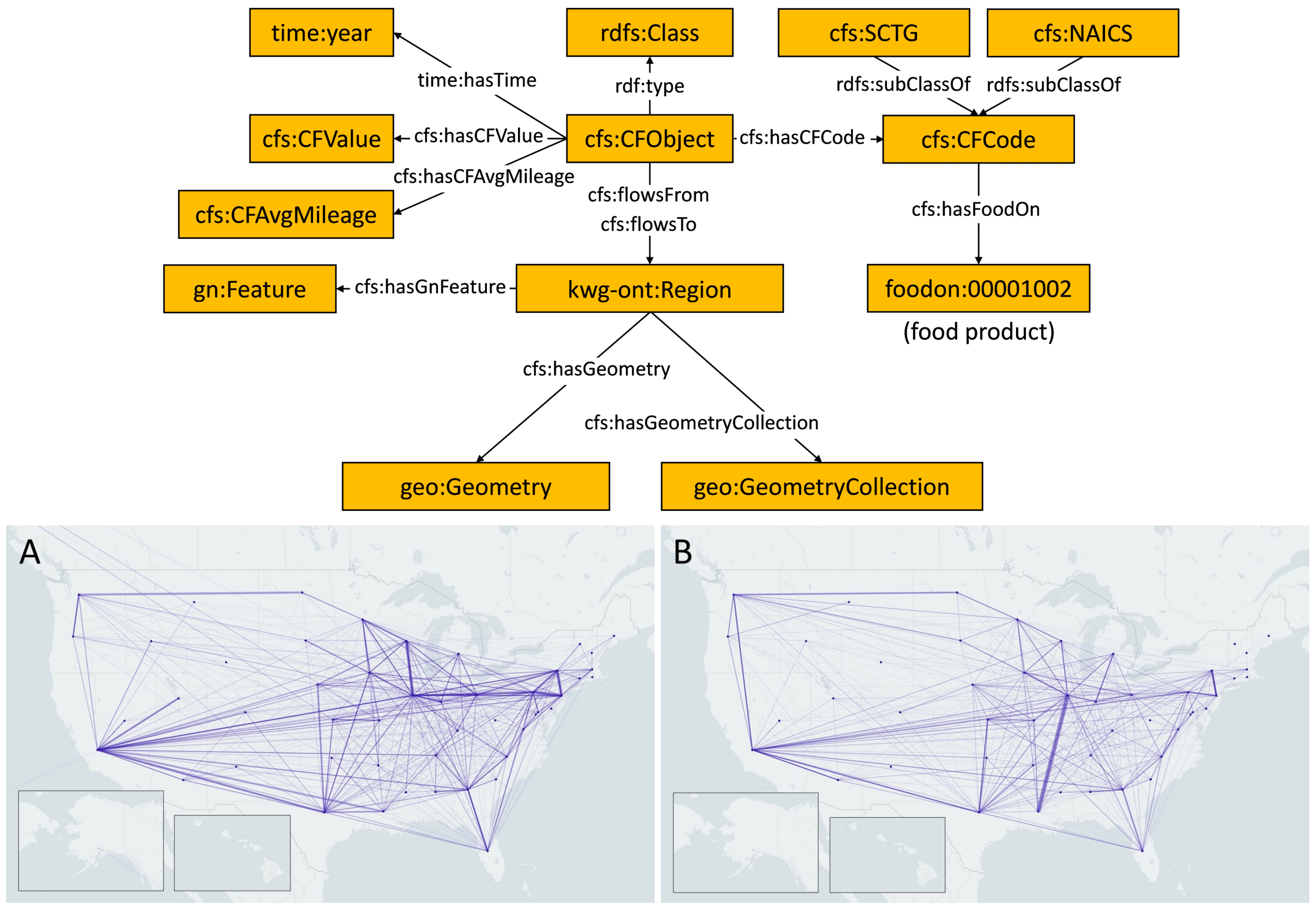 ACM SIGSPATIAL GEOKGMeasuring network resilience via geospatial knowledge graph: a case study of the us multi-commodity flow networkIn Proceedings of the 1st ACM SIGSPATIAL International Workshop on Geospatial Knowledge Graphs, 2022Highlight: Food System; Network Resilience; Geospatial Knowledge Graphs

2021
-
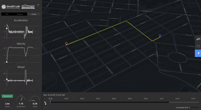 ACM SIGSPATIAL GEOAIVTSV: A privacy-preserving vehicle trajectory simulation and visualization platform using deep reinforcement learningIn Proceedings of the 4th ACM SIGSPATIAL International Workshop on AI for Geographic Knowledge Discovery, 2021Highlight: Deep Reinforcement Learning; Personalized Driving Simulation [ Video Demo ]
 -
 TGISA privacy-preserving framework for location recommendation using decentralized collaborative machine learningTransactions in GIS, 2021Highlight: Flagship Journal in Geographic Information Systems; Recognized as the first work on Federated Learning + Spatial Data Sciences (Graser, A. et al 2022)


2020


Invited Talks [ more... ]
| 2023 | Privacy and Security Issues in Large-Language-Model-powered Geospatial Applications. Applications of ChatGPT / AI at Geography According to ChatGPT, University of California, Santa Barbara [ link ] |
|---|---|
| 2023 | Mapping Mobility Changes During COVID-19 Using ArcGIS Dashboards and Mobile Experience Builder, Esri Education Sessions and Activities at AAG 2023 [ link ] |
| 2023 | Privacy-Preserving Location Recommendation via Decentralized Collaborative Learning. Texas A&M Built Environment Talk Series [ link ] |
| 2023 | Deep Reinforcement Learning for Driving Trajectory Simulation. Reinforcement Learning Seminar, Anhui University |
| 2023 | Geographic Visualization and ArcGIS Dashboards, Geovisualization and Spatial Analysis Seminar, University of Arkansas |
| 2022 | Trajectory Privacy Protection with Geospatial Artificial Intelligence, UW Roundtable on the Frontiers of Geospatial Artificial Intelligence, University of Washington [ link ] |
Recent Services [ more... ]
Program Organizers
| 2023 | PC Member, NeurIPS 2023 Workshop on Socially Responsible Language Modelling Research (SoLaR 2023) |
|---|---|
| 2023 | PC Member, ACM SIGSPATIAL 2023 International Workshop on on AI for Geographic Knowledge Discovery (GeoAI 2023) |
| 2023 | Chair, ACM SIGSPATIAL 2023 International Workshop on Spatial Big Data and AI for Industrial Applications (GeoIndustry 2023) |
| 2023 | Organizer, AAG 2023 GeoAI and Deep Learning Symposium: Geoprivacy and Ethics in Geospatial Data and GeoAI |
| 2022 | Chair, AAG 2022 Symposium on Data-Intensive Geospatial Understanding in the Era of AI and CyberGIS: GeoAI for Social Sensing |
Reviewers
- ACM SIGSPATIAL
- ACM Transactions on Spatial Algorithms and Systems
- Annals of GIS
- Applied Computing and Geosciences
- Applied Sciences
- BMC Public Health
- Computers & Geosciences
- Data & Policy
- Earth Science Informatics
- Habitat International
- International Conference on Geoinformatics
- International Journal of Data Science and Analytics
- International Journal of Geographical Information Science
- International Journal of Health Geographics
- ISPRS International Journal of Geo-Information
- Journal of Computational Social Science
- Journal of Geovisualization and Spatial Analysis
- Journal of Maps
- Land Use Policy
- NeurIPS Workshops
- Scientific Reports
- Spatial and Spatio-temporal Epidemiology
- Stochastic Environmental Research and Risk Assessment
- Transactions in GIS
Professional Appointments
| 2022 - 2023 | Committee Member, Career Development Committee, Chinese Professionals in Geographic Information Sciences (CPGIS) |
|---|---|
| 2022 - 2023 | Committee Member, Media Committee, Chinese Professionals in Geographic Information Sciences (CPGIS) |
| 2019 - 2023 | Co-Founder and Director, GISphere, a non-profit org promoting GIS-related education |
| 2021 - 2022 | Student Director, American Association of Geographers Geographic Information Science and Systems Specialty Group (AAG-GISS) |
| 2021 - 2022 | Committee Member, Graduate Study Committee, Department of Geography, University of Wisconsin-Madison |
| 2020 - 2021 | Committee Member, Curriculum Committee, Department of Geography, University of Wisconsin-Madison |
| 2017 - 2018 | Network Center Assistant, School of Resource and Environmental Sciences, Wuhan University |
Recent Awards [ more... ]
| 2023 | Peer Bonus / Spot Bonus, Google [X] / Mineral, Alphabet Inc. |
|---|---|
| 2022 | The SRGC Conference Presentation Award, University of Wisconsin-Madison |
| 2022 | Trewartha/Odebolt Conference Travel Award, University of Wisconsin-Madison |
| 2019 | Best Poster Paper, ACM SIGSPATIAL RAAS Workshop |
| 2019 | Welcome Award, Graduate School, University of Wisconsin-Madison |
| 2018 | Outstanding Graduate Student, Wuhan University |
| 2018 | Silver Award, China “Internet+” Innovation and Entrepreneurship Competition Hubei Final |
| 2017 | The 1st Prize, Wuhan University “Internet+” Innovation and Entrepreneurship Competition |
| 2017 | National Scholarship, Ministry of Education, China |
| 2015 | National Scholarship, Ministry of Education, China |